|
Baker City to Missoula |
||
 |
||
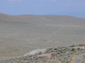
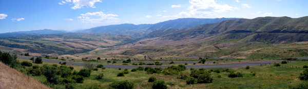
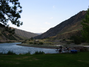
| The View from Flagstaff Hill. | ||
|
I took a day off in Baker City, to rest my sore buns. I toured the Oregon Trail Museum here, in a building that was once a combination ballroom / natatorium (indoor swimming pool). A few of the museum docents told me that they learned to swim in its pool. During World War II, the pool was paved over, and the building was used as an arms factory. The upstairs ballroom has been restored, and the former pool/factory floor houses many interesting exhibits related to early western life. I left Baker City late Friday morning, July 9th. I had been up most of the previous night, building my last dispatch page- a royal pain to upload using dial-up service. On my way out of town, I mailed home another 9 pounds of stuff. |
|
|
|
|
Just out of town, I climbed Flagstaff Hill (a speed bump), then climbed the driveway to the National Oregon Trail Interpretive Center (a seriously steep hill!). In the parking lot at the top was a loaded touring bike without a rider. I was checking out some of the outdoor exhibits, when the bike and its rider, Simon Plummer from the U. K., pulled up. He was riding the TransAmerica Trail in the other direction and was less than 600 miles from completion. We talked for almost two hours. We compared rigs- he's using a Bob trailer- and he gave me many tips for the road ahead of me. Simon is an IT consultant in the U. K., and he's also maintaining a web site, but is not carrying a computer. He's using libraries and internet cafés to upload his pages via blogger.com. He described the process, but it seemed a bit beyond my abilities as a fledgling web designer. Check out his site here. |
|
| |
||
|
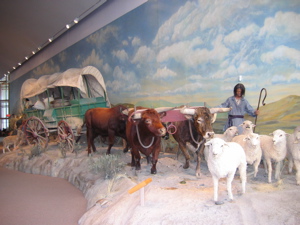
Simon headed into Baker City, and I went into the Interpretive Center to look around. I ended up spending almost two hours inside. The place is fascinating! It really makes life- and death- on the Oregon Trail come alive. Life-size dioramas depict families traveling west in wagon trains with all of their possessions, including livestock, seeking a new life in the Oregon Territory. Other displays, including movies and recordings, are effectively used to make you feel like you were there with them, sharing the excitement and danger of their journey. I left the museum feeling like I have it easy on my trip. The bicycle is the most efficient form of transportation known. I travel two to three times as far as the pioneers did on a typical day. The natives could be friendly or hostile then. Today they are overwhelmingly friendly. Some of the campsites I've visited are probably no better than the pioneers experienced, but the motels today are certainly a lot nicer! |
|
|
| Diorama
in the Interpretive Center. |
||
 |
I had hoped to get into Idaho on my first day out of Baker City, but due to my late start and my extended visits outside and inside the Interpretive Center, I didn't quite make it. I stopped at a county campground (Hewitt Park) near Richland, OR, after 50 miles. It was a pretty spot on the Brownlee Reservoir, but inhabited by noisy fishermen who were up most of the night, and more bugs than I've ever seen in one place. The walls, floors, and fixtures in the bathroom and shower were completely covered with gnats, moths, and mosquitoes. The next morning began with a healthy climb to the town of Halfway, OR, where a junior rodeo would be held that evening. I wish I could have stayed to watch it, but I needed to move on. |
|
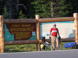
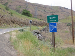
Its about time! |
||
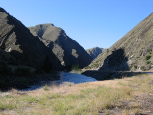
I dropped into Hell's Canyon at Oxbow, OR, then rode along the Snake River until crossing into Idaho at Brownlee Dam. I set my watch ahead one hour to Mountain Time. After 600 miles, it was nice to finally cross a state line. Not that I was happy to leave Oregon- the state and its people were beautiful, and I'll be back. After a few miles, I camped in Idaho Power's Woodhead Park Campground, a nice spot on the Brownlee Reservoir with great, clean, free showers. That evening, the wind piped up to gale force out of the South, the direction I was headed the next day. |
 |
|
| |
||
 |
Sunday morning began with a seven mile climb out of Hell's Canyon, with a nice breakfast break three miles up at the Gateway Café. I made it to Council, ID, 50 miles later, and, unable to find a campground, collapsed in the cheap, but clean, Starlite Motel. Throughout the day, I saw tons of BMW motorcycles, heading for this coming weekend's national BMW Motorcycle Owners' Association in Spokane. |
|
Rest stop along the Little Salmon River. |
||
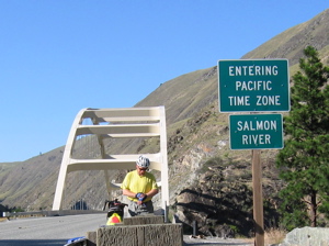
Monday, after some initial climbing, I had a nice downhill cruise for about 30 miles. Near the bottom, I crossed the Salmon River, and back into Pacific Time! The time zone follows the meandering paths of the Salmon and Snake Rivers, and I crossed it several times in each direction. After 70 miles, I pulled into a restaurant in Lucile, ID. There was a loaded touring bike with a Burley cargo trailer parked outside. I went in and found Steve from Portland, who is heading the same direction, but turning north towards the middle of the TransAm to finish near Chicago. |
 |
|
"Watch change " crossing the Salmon River. |
||
|
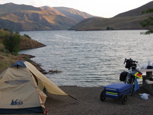
Steve invited me to join him for dinner, and I accepted (no arm twisting required.) He is a student at Lewis and Clark College in Portland. I enjoyed our conversation, but our meeting would be brief, as Steve was planning to ride another 20 miles to White Bird that evening, and I was done for the day. After dinner, I coasted to the campground behind the restaurant, picked an out-of the-way spot next to the river, and headed for the shower. On my way back to my campsite, Steve pulled up with two other riders, Kyle and Lisa, who were westbound on the TransAm. |
|
Salmon
River Campsite |
||
Kyle and Lisa graduated this spring from the University of Virginia. Kyle is from Bergen County, NJ, not far from Oakland, home of the Hoelands! Lisa is from Ohio. Kyle is planning to go to Medical School, Lisa to Law School (yuppies in the making!). Although I generally have been enjoying my solitude, it was nice to spend some time with other riders, even if I am older than their parents. I set up my tent without the fly, since it was warm and dry, and fell asleep looking at the stars through the tent netting. I woke up the next morning to find Kyle sleeping on the picnic table. Is that tent camping's version of the couch, perhaps? Steve joined me for breakfast at the same restaurant. He is also Jewish, and said that if we entered most of the towns along the route together, we'd probably more than double the Jewish population instantly. |
|
|
|
||
Old
White Bird Hill Road (The main road is visible cutting along
the butte to the right.) |
||
I pulled out of the restaurant parking lot ahead of Steve, since he was rearranging his gear. As there was a substantial climb ahead and I don't climb very quickly, I expected to see him shortly. I haven't seen him since. After a 20 mile downhill cruise, I came to White Bird. Here, I opted to take the suggested alternate route to the top of White Bird Hill. It's less steep than the main road, but five miles longer, with many switchbacks. Unlike the main road, it is almost completely devoid of traffic. Though not very long, it was the hardest climb I've ever done. It took me four hours to ride eleven miles! The temperature hovered near 100°, and the asphalt softened in the sun, so it felt like demons were reaching up from the road to grab my four tires. At one point, while I was still moving, I looked down and saw a column of ants marching in the same direction. They were passing me.
|
|
|
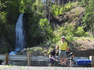
Falls
near the Lochsa River. |
||
|
The remainder of the day made up for it! The next 36 miles were downhill. I made a brief stop for supplies in Grangeville. With a population of 3,226, it's one of the larger towns on this section of the route. As I started down the steep grade from town, a red pick-up with a bale of hay and a large dog in the back waited patiently behind me until he could see far enough ahead to pass safely. As he passed, he called out, "You're gonna LOVE this hill!" And he was right! The road dropped and twisted for 11 miles, into a canyon as beautiful as Picture Gorge in Oregon. I coasted the whole way at between 30 and 35 mph, enjoying the ride so much I was laughing out loud the whole way down. The views will stay with me, as I wasn't about to interrupt my joy to take pictures. |
|
Private
cable car across the Lochsa. |
||
At the bottom, I rode in the canyon along the Clearwater River, and entered the Nez Perce Indian Reservation. Since I was still reading Steven Ambrose's Undaunted Courage, an outstanding book about Lewis and Clark's journey, this was a fascinating place for me. Here I was, 199 years after the Corps of Discovery passed through this very place- by the grace of, and with the help and guidance of the Nez Perce. Without the Nez Perce, Lewis and Clark would not have been successful, and would probably be unheard of today. Arguably, what is now the continental U.S. could have been very different today, shared between the U.S., France, Spain, and Britain. I highly suggest reading the Ambrose book, to see how truly important L & C's expedition was in shaping our country. |
|
|
Lochsa Canyon |
||
|
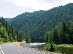
I passed through the town of Kooskia (pronounced KOOS-key). and camped at the River Junction Campground, an absolute pit! The bathrooms and pay shower were filthy, and the mosquitoes ate me alive. I showered as quickly as I could, and collapsed in my tent to eat a cold dinner. I backtracked a short distance into Kooskia for breakfast Wednesday morning, Then started my 70 mile climb up the Lolo Pass, following in the footsteps of Lewis and Clark. Lolo, crossing the Bitterroot Range of the Rocky Mountains, was the major obstacle for the Corps of Discovery in both directions, taking months to cross each way. The long, gradual climb up the Lochsa River Canyon (pronounced LOCK-saw) was beautiful. Once I passed Lowell and began the climb, the road was without any services other than primitive campgrounds for 66 miles. |
|
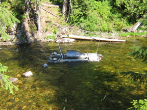
| Lochsa River
automatic gold panner? |
||
I saw plenty of birds and mule deer on the way up, but no moose or bear, though I kept looking for large game. About halfway up, I stopped at the historic Lochsa Ranger Station. The docents, the Humphreys, were a retired couple who live in Tucson in the winter, and Maine in the summer. I had a great time visiting with them. They lived near Philadelphia for almost 30 years! Dr. Humphrey was a chemical engineering professor at Penn, then Dean of that school. During this time, the Humphreys lived on Ridley Creek, just south of Philadelphia in Delaware County. He later taught at Lehigh and Penn State Universities. I sat on the porch and rested for a while at the Ranger Station, watching a group of hummingbirds do battle over a feeder. |
|
|
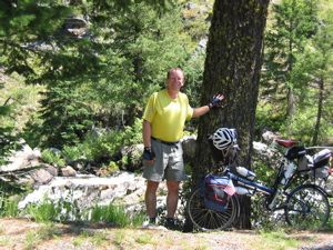
Do
I look tired? |
||
|
I spent Wednesday night at the Wilderness Gateway Campground, a U.S. Forest Service facility with flush toilets, but no showers. My shower bag did the trick. At some point while I was there, a man in the campsite just next to mine broke both of his legs while he was chopping wood. The sites were fairly far apart, and very private. I noticed the emergency lights as night fell, but had no idea what had happened until another camper filled me in the next morning. I left early Thursday morning, so I could get over the pass before the end of the day. I stopped for lunch at the Lochsa Lodge in Powell, 13 miles short of the summit, and had a great Reuben sandwich. Then, I made my summit push, getting there at 7:00PM, which instantly became 8:00PM, since I crossed into Montana, and back into Mountain Time at the top. |
|
Lolo Hot Springs |
||
From the summit, it took me 15 minutes to coast the eight miles down to Lolo Hot Springs, an historic spot turned tourist trap. The Lewis and Clark expedition, along with their Nez Perce guides, stopped and enjoyed themselves at this spot, after crossing Lolo Pass. I checked into a motel there, since the campground looked about as inviting as River Junction, back in Kooskia. Friday morning, I coasted down to the town of Lolo, stopping at the site of "Fort Fizzle". Here, in 1877, Nez Perce under Chief Joseph, who were trying to avoid relocation into a reservation, slipped around a fort which had been hastily constructed to block their escape. 13 miles after Lolo, I entered Missoula, and pulled up to the headquarters of Adventure Cycling Association, the organization that planned and mapped the TansAmerica Bicycle Trail, as well as many other routes. There were ten loaded touring bikes parked outside. I went inside and signed in. There were cycle tourists milling about everywhere. I signed in, but felt completely anonymous. I wasn't expecting a hero's welcome, but I guess I wasn't expecting to be ignored, either. |
|
|
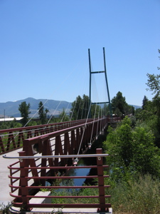
Bike
bridge into Missoula. |
||
|
I looked around for a few minutes, then walked outside. I went to take something (my phone?) out of the bag that holds my valuables, and bobbled my camera. It dropped onto the sidewalk with a heartbreaking crunch, plastic pieces flying in all directions. I gathered the pieces, sat down under a tree, and just about cried. I bought the camera specifically for this trip. It's a bit heavy, but has otherwise been perfect. I know I have to expect occasional unexpected expenses. Most of them are unavoidable- like bike or equipment repairs. But to suffer a major expense for no other reason than my own stupidity was tough to bear. I walked back inside Adventure Cycling to ask about a camera shop, and things began to change for the better. |
|
Adventure
Cycling Headquarters |
||
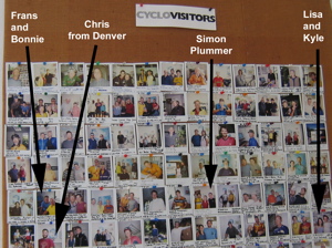
The cyclists there were all a part of an Adventure Cycling group, westbound on the TransAm. I had been ignored because the staff thought I was a part of their group. As the group packed to leave, they realized I wasn't. Larry Diskin, AC's Education Coordinator, introduced himself and gave me a tour. He grabbed a Polaroid camera and took my picture for their wall. Another staffer, a laid-back guy maybe a little older than I, inquired about my bike and trailer- an unusual setup, he said. He asked if he could take my portrait for their gallery. He handed me a model release form to sign. The form named the photographer as Greg Siple. "Are you Greg", I asked. He was. Greg Siple co-founded Adventure Cycling, and is still their Art Director. As a member of Adventure Cycling, I have been reading about him for years. In fact, he is one of the major inspirations for my trip (as I would guess he is for many cyclists riding across the country). You can read more about Greg here. |
|
|
Adventure
Cycling's picture wall, showing a few of the riders I've met . |
||
Greg had me grab my bike and meet him on the other side of the building, where he took my picture. He spent quite a bit of time with me, even as it grew late on a Friday evening. He gave me a sticker which reads, "I ride, therefore I TransAm", which I will proudly display on my bike. We talked about my trailer, the most unusual part of my rig, and its pros and cons. He took me back to the photo gallery, which had large prints from the original Bikecentennial TransAmerica Tour in 1976, all over the walls. (Greg was on that trip, of course.) Greg told me that these photos were kept here as an inspiration to the staff. Although the equipment and clothing has changed in the 28 years since that tour, not much else in the photos has. The sport is growing, but people still do the TransAm and other tours for the same reasons, and enjoy similar experiences as the original group. Though laid-back, Greg was clearly excited about what he had begun here, and how Adventure Cycling has encouraged so many people to tour on a bicycle. It was an honor to meet and talk to Greg Siple, and an even greater honor that he asked to take my portrait. And, on top of that, after I put the pieces back together (and an initial hesitation on its part) my camera seems to work!
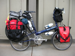
I left Adventure Cycling and headed to REI. Earlier in the week, I had stopped at a library and ordered some waterproof Ortlieb panniers (saddle bags) from rei.com, and had them shipped to their Missoula store. I picked them up at the store, and tried them out. They mounted to the bike without any interference with pedaling, a big concern because of the short wheelbase of my small wheeled Bike Friday. And, I got all of the gear from my trailer in them! That means a huge weight reduction without losing any gear! |
||
|
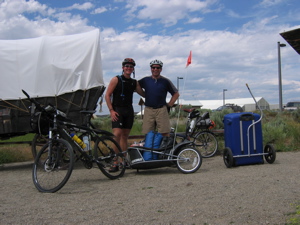
I sent the trailer home. The package weighed 32 pounds! With an increase of about 5 pounds worth of new panniers, I reduced my load by 27 pounds, and reduced my drag at the same time. (Yes Woody, you were right!) I discuss this more here. I also bought a new saddle in Missoula, and sent home my Brooks. While many long-distance cyclists rave about the comfort of Brooks saddles, for a few people they just don't work. It seems that I am one of those few. I also replaced my helmet, which had inexplicably cracked in several places, and had my bottom bracket (the set of bearings around the pedal axle at the bottom of a bike frame) repaired at the Bike Doctor, where I found excellent mechanics. I spent two days in Missoula, building this page, testing and adjusting my new rig, and sitting out some rain. I was ready to leave on Monday morning, July 19th, headed for Yellowstone. |
|
|
|
New Rig! |
||
Next Dispatch: Missoula to West Yellowstone |
||