|
West Yellowstone, MT to Rawlins, WY Including Yellowstone and Grand Teton National Parks |
||
I spent Sunday night, July 25th, in a cheap motel in West Yellowstone, Montana. I left the window open that night, trying to ease the stuffiness of the room. In the middle of the night, I was awakened by the sound of the parking lot trash can being upset, and the rattle of empty cans and bottles on the pavement. I looked out my window, and saw a large shaggy dog trotting away from the scene of the crime. Before I left the motel for Yellowstone Park the next morning, I had a nice chat with the motel owner's husband. He had cleaned up the trash can mess first thing in the morning, and found large teeth marks in some of the trash. I told him about the dog I saw. "That was no dog", he said. "The Yellowstone wolves are getting pretty bold." I hoped to see more wildlife in the park, in a more natural setting. After breakfast in town, I did some grocery shopping, then spent some time on the phone with Tom (Amanda's dad) and the attorney who was setting up Amanda's Miracle Helpers. We've hit a major roadblock in going for non-profit status. To make the story short, a non-profit organization cannot be created with a single beneficiary, like Amanda. After almost an hour on the phone with the attorney, she convinced me that non-profit status would prevent Amanda from benefiting from our fundraising efforts to a great extent. (She had already convinced the Hoelands, but I am stubborn.) She recommended we skip non-profit status, and focus on raising money for Amanda. I believe our hearts were (and are) in the right place. Our cause hasn't changed. If we can better help Amanda without non-profit status, we will. The Hoelands and I will still pursue the creation of Amanda's Miracle Helpers. It will take some time, and a lot of effort. But Amanda and other children like her have so much to gain from any help we can provide. In the meantime, we are off to a great fundraising start, and those efforts will continue. If you have already made a donation to Amanda, rest assured that 100% of the funds will go directly towards care and equipment for her. Absolutely no donated funds will cover any expenses of my journey, or any administrative or fundraising expenses. If you haven't yet made a donation, you may send one directly to Amanda using the information here. This site will provide regular updates about any care and equipment purchased for Amanda with your donations. We now return you to our regularly scheduled dispatch. |
||
|
|
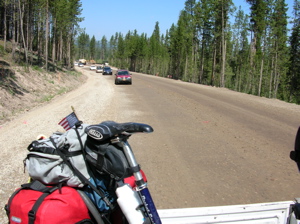
Yellowstone, the world's first national park, begins right at the edge of the town of West Yellowstone. I showed my Golden Eagle Passport at the gate, listened to the ranger's spiel about how crazy I was to ride a bicycle through the park (which west-bound bikers had told me to expect), and headed towards the Grand Canyon of the Yellowstone River. The Canyon area is not on the TransAm route, but I was told it was a "must see!" So I planned to ride about 50 extra miles to see it. The change from the bustle of West Yellowstone to the park was dramatic. Once the entrance gate was out of sight behind me, the only evidence of human contact with the land was the road on which I pedaled. Traffic was light, and most of it was heading in the other direction- out of the park. The road was fine, with enough shoulder to keep me to the right of the fog line, and what little traffic was going my way was courteous. |
|
|
There was abundant evidence of the massive fires that swept the park in 1988, but also signs of re-growth and recovery. Just a few miles after entering the park, I crossed the state line into Wyoming. A few miles after that, at Madison Junction, the TransAmerica trail went to the right towards Old Faithful, and I went left towards the Canyon. I rode along the Gibbons River past Gibbons Falls. In this area, the road was in poor condition. But it was to be one of the few places in the park where that was the case. Traffic was light, and I didn't have any problems here. |
|
|
|
The land began to show evidence of the underground violence that has occurred here for millennia. Abrupt changes in terrain resulted in waterfalls and cliffs. A strong smell of sulphur was quickly followed by the sighting of a steam vent, hot spring, or geyser.
Tourist traffic, both auto and foot, was light, and thinned out even more as the day wore on. I had several viewing platforms to myself for periods of time. The road sometimes rolled, sometimes climbed and dropped steeply. My riding strength surprised me here. Even with my touring load I was able to maintain momentum through the rolls, and I felt good climbing the steeper hills. Maybe I'm finally getting into shape! |
|
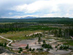
The "Artist Paint Pots", highly recommended by my Dad and Rebecca, my step mom, were incredible! Mineral pools dotted an area of about a half mile square on several levels going up the hillside. Depending on the minerals in the water, or sometimes even in the mud, the pools displayed different colors- mostly a rich variety of earth tones, but also some vivid blues and whites. The colors may have been muted because of an overcast sky, and they were still amazing! Leaving the Paint Pots, the road climbed steeply uphill- 8% for three miles, according to a sign. I pushed hard up the climb, alternating sitting and spinning at a fairly high pedal cadence with standing and pushing a bigger gear. Several of the few cars left on the road cheered me on as they passed. (It helped to have an audience.) |
|
|
|
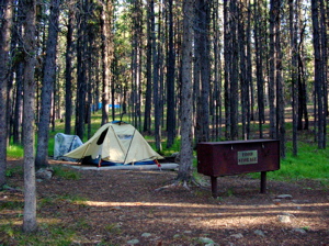
It was late in the evening and starting to sprinkle when I pulled into Canyon Village. I pulled my bike under the overhang of the huge lodge there, and went inside to find dinner. The cafeteria special was trout almondine, and, along with a chef's salad, several sides of vegetables, a large dinner roll, soup, and a generous slice of apple pie, it hit the spot! When I finally checked in to the Canyon campground, the rain had stopped, but it was getting dark. A sign at the entrance said that the campground was full, but I had been told by bikers to ignore that. There are always "hiker/biker" spaces available. The ranger at the check-in window gave me the bear spiel. (I had been warned to expect that, too.) In a nutshell: "This is bear country. Bears who find an easy meal of human food can become aggressive, and then usually must be destroyed. Don't cook, eat, or store food in your tent. All food, beverages, toiletries, and cooking gear must be stored in a vehicle when not in immediate use. Don't be responsible for the death of a bear!" |
|
Canyon Camp |
||
Since hikers and bikers don't have a vehicle in which to store food, the hiker/biker areas provide "bear boxes"- heavy cast iron food storage boxes that secure with chains. The hiker/biker area was in a woods of tall trees, off by itself, but an easy walk to the showers and laundry facilities. There were pads for about ten tents. I was the only one there. The nearest campers were several hundred yards away. This being my first experience in bear country, I was kind of freaked out. I set up my tent in the dark. By now, I had set it up enough times in daylight, but it still surprised me that it went up so easily. I loaded all of my stuff into the bear box, and headed to the showers. On the way back, I briefly considered setting up my sleeping bag in one of the other bear boxes, but my claustrophobia won out over my fear of bears. And wolves. Barely. My middle-of-the-night pee in the woods in the pitch black was a traumatic experience, to say the least, not to mention cold. |
||
|
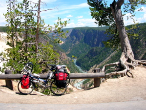
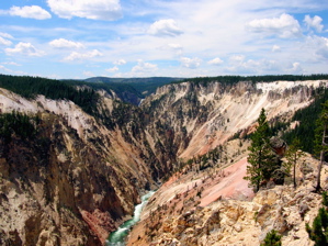
When I woke in the morning, the temperature was in the mid-thirties. (Most of Yellowstone is above 8,000 ft.!) I put on just about every piece of clothing I had, and went back to the lodge for breakfast, then explored the shops there. I bought a few gifts for my nieces, and mailed them from the post office next to the lodge. Then, I packed up and took off to explore the canyon. It didn't take more than one look to see why I was told the canyon was a "must see." One picture should do it for you. Pick any one of these. I explored the area by road and on foot. The viewpoints were pretty crowded. In many areas, I was competing for a viewing spot with a busload of German tourists. But if I took a few steps off the road and onto the trails, the crowds were manageable. |
|
The trickiest job was finding parking for my bike. There were no bike racks anywhere. Several times, I thought I found a good spot, only to have the German tour bus pull up with the bus door right at my bike. So, I moved on until I found a better place. The canyon walls were loaded with active geothermic vents. The activity covered the walls with a rainbow of colors, like the Artist Paint Pots on grand scale. |
|
|
|
|
Signs around the area described the changing landscape. One observation platform crumbled during an earthquake in 1975. The sign in that area read, "Before the earthquake... this observation platform extended 100 ft. further into the canyon. The earthquake shattered a portion of this cliff, tumbling it into the gorge." "Up and down the canyon you can see evidence of other rockfalls. This section of the Yellowstone River overlies a major fracture zone, and the park records thousands of minor tremors annually. Do not assume the scenery will be the same when you return." Whether by earthquake or fire, I hoped the scenery, and I, would survive a few more days, at least until I left the park. |
|
My pictures don't do the rock spires and formations, or anything else in the canyon justice. This place should be on everyone's "must see" list. If I had to pick one area of Yellowstone to visit, the Grand Canyon of the Yellowstone River would be it. Just upstream from the canyon, the peacefulness of the Yellowstone River belied what was just around the bend. |
|
|
|
|
If I wanted to reach the campground at Grant Village, almost 40 miles south of the canyon area, before nightfall, I needed to get moving. And the road on the way was under construction, so I could expect delays. I could have spent a week at the canyon, hiking the trails down into the gorge. But I have promises to keep. Or something like that. |
|
|
||
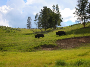
Just south of the canyon area, on the way to Grant Village, is the Hayden Valley, the home of most of the park's bison. This was another reason for my detour from the TransAm route, as the route doesn't go through here. As soon as I entered the valley, a big old buffalo bull decided he wanted to get to the other side of the road. It must be neat to be that close to a bison if you in the safety of a steel cocoon (a car), but I wasn't. The cars were playing chicken with the big guy, so I just got out of the way. (Check out the Golden Retriever in the car. He couldn't decide which was more interesting- the buffalo, or the nutcase on the bike!) |
||
|
The bison made it safely across the road, and the traffic, including me, moved on. The valley was incredibly gorgeous. Traffic moved slowly, and I was able to take a few pictures as I rode along. There were herds of bison scattered around the valley. Some small groups were close to the road. Further away were hundreds of the beasts.
Soon, I reached the area of road construction, and traffic came to a standstill. I kept my place in line, but when the road dropped to a single lane and the traffic picked up speed, it was difficult to keep up on the old surface.
|
|
Half of the road was brand spanking new. I mean seconds to minutes old! But they weren't letting the cars on it yet. As I rode past a steamroller putting finishing touches on the new half of the road, its driver called out to me, "Ride on the new stuff!" He didn't need to ask twice. I hopped onto the new side, and had the brand new lane all to myself. My friend Joe (Admiral Parts) Barolin calls new road "happy top." And happy I was! It started to rain, and I stopped briefly to pull on my jacket. But the rain didn't bother me a bit. Soon, the single lane of traffic to my left got ahead of me, and I was all by myself, riding in the rain on "happy top", and loving life!
|
|
|
|
The bison were everywhere. I watched a bull following a cow along a hillside. She was probably in heat. Every few seconds he would bellow as he walked along. The cow hesitated for a moment, and peed a bit. The bull let out a huge low bellow that sounded like the loudest belch I ever heard! Then, he took a giant piss right on top of where the cow peed, and dropped down and rolled around in it for a few seconds, rolling completely over twice. Then he got up and began following her again, belching as he went. (Are you paying attention to this, kids? It's educational.) I wish I could have taken a video of the scene, but it all happened too quickly, and all I got was one photo. |
|
|
|
|
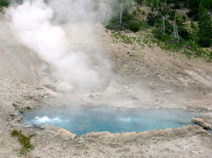
The next geologic feature I came to was the "Mud Volcano". This was really cool! A big mud puddle that kept bubbling and leaping up, spouting steam the whole time. Nearby was the "Dragon's Mouth", the mouth of a cave that spouts boiling water and hydrogen sulfide gas. (Video coming soon.) |
||
|
||
Further along the road, I came across a small herd of bison, just next to the road. One fairly large bull was within two feet of the shoulder were I was going to ride. I crossed the street, instead. (I do it walking in Philadelphia all the time, so it made me feel right at home!) The cars were pulling right up to him to take pictures. I was happy with one from the other side of the street. It was already evening when I came to Yellowstone Lake, and I still had 20 miles to go to Grant Village campground. So I stopped at the Lake Lodge for a quick dinner. I asked the two young women working behind the fountain counter if the road to Grant Village was hilly. (One was from Romania, the other from Russia. They were both gorgeous.) The first woman said, "No, it's not hilly at all." Then the second one chimed in. "Are you nuts?! It's very hilly!" Thanks for the help, ladies. I ate my soup and sandwich quickly, and moved on. |
||
I got to the Grant Village campground near dark, my rear tire going flat in the last mile. I checked-in, listened to the bear spiel again, and raced to set up my tent before the showers closed. I just made it to the showers in time, it being about a half-mile walk from my campsite. I emerged from the shower building in the middle of a thunderstorm, so I waited it out there, and walked back to my tent in a light drizzle. My tent kept me warm and dry through some showers that night, and the plastic tarp over my bike did the same for it. I left the flat tire to fix in the morning. I planned to stay at Grant Village two nights, even though the campground there was nowhere near as nice as the one at Canyon. The hiker/biker sites are mixed in with all the others, and then there's the half-mile walk to the showers and laundry facilities. But the logistics make sense. A two-night stay here allowed me too make a day trip to catch Old Faithful, heading out of the park the following day. |
|
|
I always wanted to do this! |
I fixed the flat first the next morning, ate some breakfast (peanut butter, banana slices, and craisins on a couple of bagels), left my bags in my tent, and headed off on the 20-mile ride up to Old Faithful. This was a hilly trip, crossing the Continental Divide twice in each direction! I was glad to be running light. I had my handlebar bag with my wallet (really just a plastic bag) and camera, and my rack pack with my rain gear and a few snacks. I figured I was running about 40 pounds lighter than usual. My Bike Friday felt like it was flying! At the first Divide crossing, I took a self-portrait while pouring water from my bottle onto the divide. Theoretically, half will end up in the Atlantic, and half in the Pacific. (In practice, I'm sure it all just evaporated.) A silly, but fun gesture! I took a rest stop near the next Divide crossing, and while I was there, a tandem couple pulled up from the other direction. Barb and Randall Angell sold their house in Michigan, quit their jobs, and are riding their tandem from the Arctic Circle, 200 miles north of Fairbanks, Alaska, to Key West, Florida! They are pulling a BOB trailer, and are also maintaining a web site. Check it out at www.teamangell.com They are an amazing team. They were so nonchalant about their journey. I spent about 20 minutes with them (wishing I could spend more), then they took off towards the Tetons, and I went off in the other direction towards Old Faithful. Just after we parted, I realized, too late, that I hadn't taken a picture of them. |
|
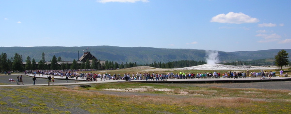
The crowd gathers for Old Faithful. |
||
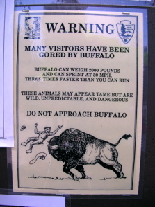
After everyone I spoke with about Old Faithful broke down the hype, I wasn't expecting much. But I was pleasantly surprised. It was worth seeing, if only to watch the spectacle of the gathering crowd as the predicted time approached. Old Faithful went off about two minutes after the prediction, close enough for me. And the two-minute spout was actually pretty impressive. Watch part of it here (coming soon.) After the eruption, I headed back towards my campsite. On the way out of Old Faithful Village, a lone bull bison was grazing near the parking lot. A bunch of people had gotten out of their cars, and were standing fairly close to him, taking pictures. I guess the warning signs posted all over the park didn't mean much to them. |
Posted everywhere in the park, often ignored. |
|
The view from the pilot car. |
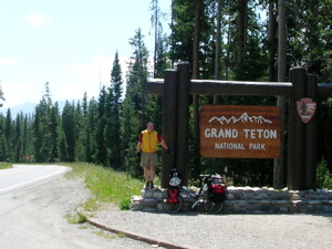
I left Yellowstone the next morning, Thursday, July 29th, headed for Grand Teton National Park. There was road construction in part of the the seven mile stretch between the parks, and bicycles had to ride in the back of the pilot car (actually a pick-up) for four miles over that portion of the road. My plan was to ride every mile of this trip, but after a look at the road, I didn't argue. |
|
Another "don't miss" spot, according to west-bound bikers, is Jenny Lake in the Tetons, an extra 16-mile long ride in each direction. I entered the park, and was a little disappointed to see that the Tetons were somewhat obscured by smoke in the air, from forest fires in eastern Washington, according to a ranger. But the mountains were impressive, still. I stopped at Colter Bay Village in the park (named after John Colter, a member of the Lewis and Clark expedition who returned to the west and became one of America's first "mountain men." ) Here, outside of the store, I met Zeke, a chef at the nearby restaurant, who was riding a tricked out GT road bike. He was a blast to talk to, and recommended his beef stew in a bread bowl at the cafe just down the parking lot. I tried it, and it hit the spot. |
|
|
Lakeside Stroll |
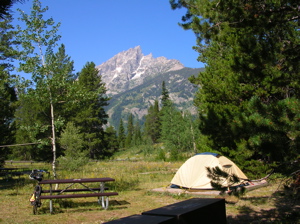
I continued towards Jenny Lake, stopping to take some pictures of a young black bear out for his afternoon exercise. He took a brief swim, then got out of the water and jogged along the beach into the woods. It was my first bear sighting. The mountains got closer as the day wore on, and I neared Jenny Lake after 60 miles or so. I got to the store near the Jenny Lake campground just before it closed, and bought a few cans of franks and beans for dinner- almost as tasty as Dinty Moore! The hiker/biker section of the campground was perfect, with a view of Grand Teton just across the lake. There was only one other person in the section, a hiker, and I went over to talk to him after dinner. He was a Brit, who had spent the last two days in the back country up in the mountains. |
|
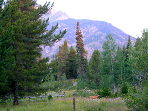
As we spoke, Big Ears the mule deer came out of the woods and taunted me, knowing that it was near dark, and my camera was back at my tent, anyway. Se walked within 20 feet of us! There were no showers at the campground, so I walked down to the lake and took a brief dip- chilly in the evening air, but refreshing. I got up early the next morning, and there in the campground was Big Ears, with her sister, daughter, and niece. She didn't get too close, but I finally got a picture of her! The kids were a hoot to watch. They bounded like kangaroos, landing and taking off on all four hooves at once. But they never got close enough for me to get a decent picture of them. |
"Big Ears" at Jenny Lake Camp |
|
|
I took an early boat ride across the lake, a short-cut to a hike up into the mountains. The scenery in every direction was breathtaking. The captain of the boat gave me the bear spiel. This one was particularly serious. This was Grizzly country, and you don't mess around with Grizzlies. The captain warned me to make noise while I hiked, so I didn't surprise a Grizzly mom with her cub, as that would almost surely be fatal. Many hikers wore little bells, he said, but he suggested singing. Carrying pepper spray as a defense against Grizzlies was a good idea also, he told me, but I didn't have any. And, I should be especially alert for fresh Grizzly signs, like scat. (Scat is the scientific term for poop.) "How will I recognize Grizzly scat", I asked. "It has little bells in it, and smells like pepper." |
|
My hike was great. I went by Hidden Falls, which I couldn't see, and up to Inspiration Point, where I was inspired. I saw plenty of scat, but I think it was horse scat. No bells, just hay and oats. The trails were very quiet, other than my singing, which didn't embarrass me since the only ones who heard it were me and the Grizzlies. |
|
|
|
I spent a few hours on the trails, then took the boat back to my campsite. I put on my swimsuit, and took a walk around the lake, far enough away from the marina area that I was in splendid isolation. I had a wonderful swim. The bottom was rocky, and my flip-flops kept falling off, but they floated, and I always recovered them. I had thought about bringing a pair of Teva type sandals for such occasions, thinking I might hike in them, too. But they wouldn't have been worth their weight for the once or twice I would use them on the trip, so I didn't think about them anymore. The water temperature was a perfect match for the warm Noontime air. I didn't want to leave. |
|
But, move on, I must. I got a great view of the Teton group on my way out of the park. A few miles outside the park, after 45 miles on the road, I stopped in Hatchett at the small resort there. I inquired about a room, and was quoted the "special discount" rate of $99 for a night. A nice little US Forest Service campground was right next store for $8, so I passed on the room. I did pay them $7.50 for a shower though, and it was worth every penny! I also enjoyed dinner in their restaurant before moving to the campground next door and setting up my tent. The only other camper there was a Dutch cyclist going the other way, and we spoke briefly before I dove into my tent to escape the skeeters. I was awakened after dark by the sounds of several auto-campers pulling in and setting up, and not very quietly, either. When I woke up, the little campground was almost full! |
|
|
|
||
|
I left Hatchett reasonably early Saturday morning, July 31st, after a breakfast of peanut butter bagels and oatmeal. (It was cold!) The day's route was a climb to Togwotee Pass (TOE gwet tee), at 9,658 feet, the second highest summit on my entire trip. I took a rest stop at a University of Wyoming "Forest Management Demonstration Area". One of the signs here described some of the "benefits" of clear cutting. "Carefully designed clear cuts can provide scenic vistas along highways such as this."
|
|
Continuing up the hill, I passed the remains of a smashed iPod on the shoulder. I was having some computer problems at the time, and I understood the sentiment, exactly. |
|
|
|
||
Fishing lake at Togwotee. |
I pretty much breezed up the pass. Just past the top, there was a cute little fishing lake, with mountains towering above it. The scenery in the Wyoming Basin on the other side of Togwotee Pass was different than anything I had yet seen. It reminded me a little of Picture Gorge in Oregon, with painted hills on both sides of the road. The trip down to the town of Dubois was a blast. The downhill was a little disappointing- not nearly as steep as the climb on the other side. But a rare stiff tailwind made up for it, and I finished the last 25 miles into town in exactly an hour. |
|
Dubois (accent on the first syllable, pronounce the "s") is like many western towns I've been through. The largest, most prosperous shop always seems to be the taxidermist, and parts of dead animals hang in every available space in the cafes. If you hit the spot most popular with the locals, you may even pick up a small taste of western small-town xenophobia- the signs on the cafe walls (hung between dead animal parts) with messages like, "Kill a wolf, save 10,000 elk"; or "Shoot a tree hugger, save 100 jobs." (Really!) But, if you open the door to conversation, the people are almost always pleasant and friendly- sometimes so friendly that you'll get tied up in conversation for the better part of an hour when you're ready to leave! Dubois is home to the National Bighorn Sheep Interpretive Center (which was closed while I was in town). More of these animals live in the hills south of town than anywhere else in the world. I checked into the Super 8 Motel in town, hoping to get an early start the next morning, and also hoping the wind would stay out of the west. |
|
|
|
It didn't. On Sunday, August 1st, I started out with a tailwind. I covered the first 20 miles in an hour. Then, the wind flipped around out of the east. I rode the last 60 miles upwind to Lander, most of it through the spectacular scenery of the Wind River Indian Reservation. I took my last break in the town of Fort Washakie, stopping at a convenience store for some snacks, and talking to some native kids about my ride, and about life in general. In Lander, I showered in a motel (a bargain at $5!), had dinner at the Cowfish Brew pub (maybe the best meal of my trip, so far!), and camped in the large city park. There were 15-20 camping tents there, but I was the only bicyclist. There was a motorcycling couple near me, but they were in the tent when I set up camp, and still in the tent when I left the next morning. |
|
From Lander, I rode 60 miles to Jeffrey City, through desolate but beautiful country known locally as the Badlands. The day featured a difficult 30-mile climb (headwind included at no extra charge) to the top of Beaver Rim. Jeffrey City (population 106) looked all but abandoned. There was one cafe, and a motel that looked deserted but was actually clean and comfortable. |
|
|
|
I was on the road by 7:00 Tuesday morning for the 80-mile ride to Rawlins. The area around Jeffrey City was supposedly loaded with Pronghorn (kind of like antelope), but, though I kept a watch for them, I didn't see any. I did see Big Ears the mule deer though, whom I have seen almost every day of my trip. 20 miles out of Jeffrey City, I came to Split Rock, which was a landmark for the three historical routes that passed this way- the Pony Express, the Oregon Trail, and the Overland Stage. |
|
The Pony Express may have been the most romanticized of the three, but it was the shortest lived, ending in bankruptcy after only 18 months. I pulled into Rawlins late Tuesday evening, August 3rd, checked into the Best Western Motel (which offered free high-speed internet), grabbed dinner in the motel restaurant, and went to bed. |
|
|
|
That night, I dreamt I was riding along and Big Ears came bounding out of the woods and knocked me over, then stood on my chest as I lay on the ground. She stared at me angrily. I looked up, and noticed a piece of note paper in her mouth. I reached up and grabbed the note. It said, "MY NAME IS TAYLOR!!" |
|
Slide
Show of This Section (Coming Soon) |
||
| Previous Dispatch, "Missoula to West Yellowstone " Dispatch Menu | ||
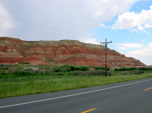
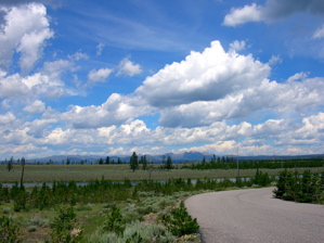 Still
big sky (just before leaving Montana), with fire scarred
but recovering ground.
Still
big sky (just before leaving Montana), with fire scarred
but recovering ground. 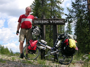
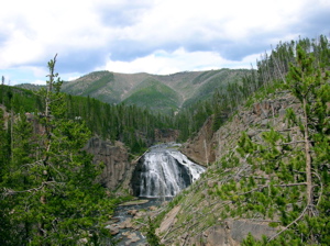
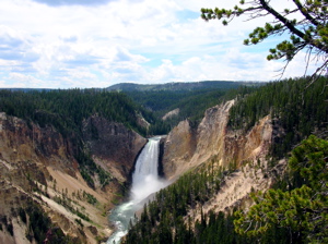 The
Lower Falls of the Yellowstone
The
Lower Falls of the Yellowstone 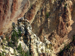 Rock
formations in the canyon.
Rock
formations in the canyon. 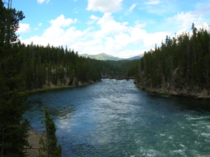 Yellowstone
River, above the canyon.
Yellowstone
River, above the canyon. 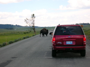 Too
Close for Comfort
Too
Close for Comfort Big
solitary bull.
Big
solitary bull.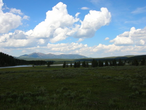
 Bull
chasing cow- "Hey, baby! (BURP!)"
Bull
chasing cow- "Hey, baby! (BURP!)" 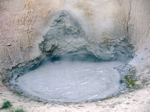 Mud
Volcano
Mud
Volcano 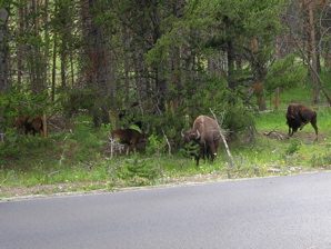 Still
Too Close!
Still
Too Close! 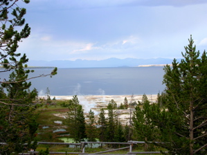 Hot
springs on the shore of Yellowstone Lake .
Hot
springs on the shore of Yellowstone Lake . 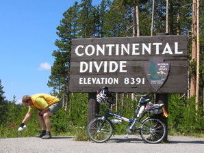
 Teton
Entrance
Teton
Entrance 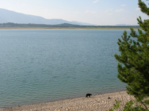
 Early
Morning at Jenny Lake Camp
Early
Morning at Jenny Lake Camp 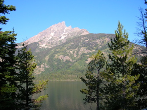 Grand
Teton from Jenny Lake
Grand
Teton from Jenny Lake 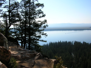 Inspiration
Point Trail above Jenny Lake
Inspiration
Point Trail above Jenny Lake 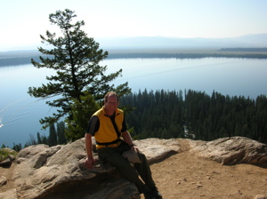 At
Inspiration Point
At
Inspiration Point 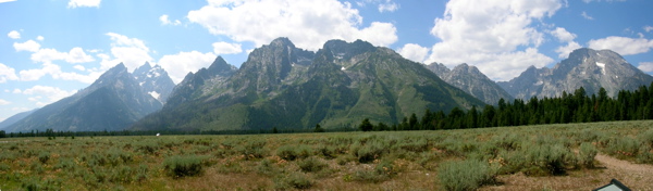 Tetons
through smoke.
Tetons
through smoke. 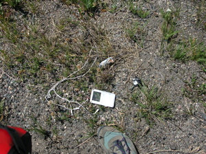 Looks
like I'm not the only one pissed at Apple!
Looks
like I'm not the only one pissed at Apple! 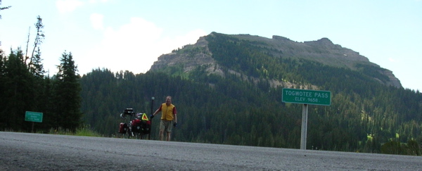 Togwotee
Pass
Togwotee
Pass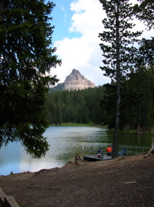
 Colorful
Hill coming into Dubois.
Colorful
Hill coming into Dubois. 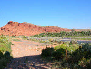 Wind
River Butte
Wind
River Butte 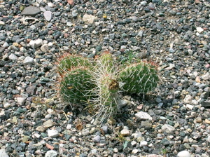 Cactus
in the shoulder.
Cactus
in the shoulder. 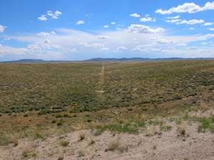 Oregon
Trail wagon ruts.
Oregon
Trail wagon ruts. 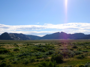 Split
Rock
Split
Rock 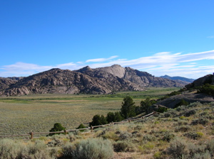 Split
Rock Meadows, on the Pony Express, Oregon, and Overland Stage
Trails.
Split
Rock Meadows, on the Pony Express, Oregon, and Overland Stage
Trails.